
The British North America Act of 1867 created the Dominion of Canada through Confederation, establishing a federal system that united four provinces while laying the foundation for westward territorial expansion across the continent.
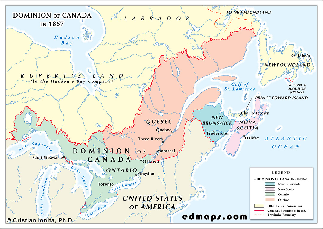
Confederation initially comprised four provinces: Ontario (former Canada West), Quebec (former Canada East), Nova Scotia, and New Brunswick. Ontario and Quebec were carved from the former Province of Canada, restoring distinct provincial identities while maintaining federal unity. Ontario encompassed the Great Lakes region with approximately 1.4 million inhabitants, while Quebec retained the St. Lawrence valley with roughly 1.1 million residents, preserving French civil law and Catholic institutions.
The new constitution established a federal system with the Dominion government in Ottawa controlling defense, foreign relations, trade, and criminal law, while provinces retained authority over education, civil law, and local matters. This division addressed the cultural and linguistic tensions that had plagued the Province of Canada.
The Dominion's western boundary initially extended only to Lake Superior, leaving vast territories under Hudson's Bay Company control. The eastern provinces retained their existing boundaries, while Ontario's northern boundary remained undefined, extending theoretically to Hudson Bay.
The Northwest Territories remained under Hudson's Bay Company administration, encompassing present-day Manitoba, Saskatchewan, Alberta, and parts of Ontario, Quebec, and the Arctic. British Columbia existed as a separate crown colony following the 1858 gold rush, while Prince Edward Island remained an independent colony.
Each province possessed its own lieutenant governor, premier, and legislative assembly, while the federal government operated through a Governor General, Prime Minister, House of Commons, and Senate. This Westminster-style parliamentary system provided the governmental structure for managing the new federation.
Confederation architects envisioned continental expansion, with plans to acquire Hudson's Bay Company territories and incorporate British Columbia, creating a transcontinental dominion from Atlantic to Pacific.
Sources, Methodology & Educational Use: The maps presented on this page are original creations produced for edmaps.com by Dr. Cristian Ionita. Each map is based on verified historical data relating to the territorial evolution, administrative structures, and political history of Canada. The maps are designed according to established practices in historical cartography, including source analysis, period contextualization, and visual clarity. The collection is curated to support teaching, learning, and public understanding of Canadian history, and is intended for educational and non‑commercial use.
edmaps.com — Historical Cartography for Education
edmaps.com provides original maps and curated historical maps designed to support teaching, learning, and public understanding of territorial evolution and administrative history. The original maps are created by Cristian Ionita, and all curated maps are selected from public archives, historical collections, and private holdings, and are presented for educational and non‑commercial use.
© Cristian Ionita. All rights reserved.
Website: https://edmaps.com — Contact: info@edmaps.com
