
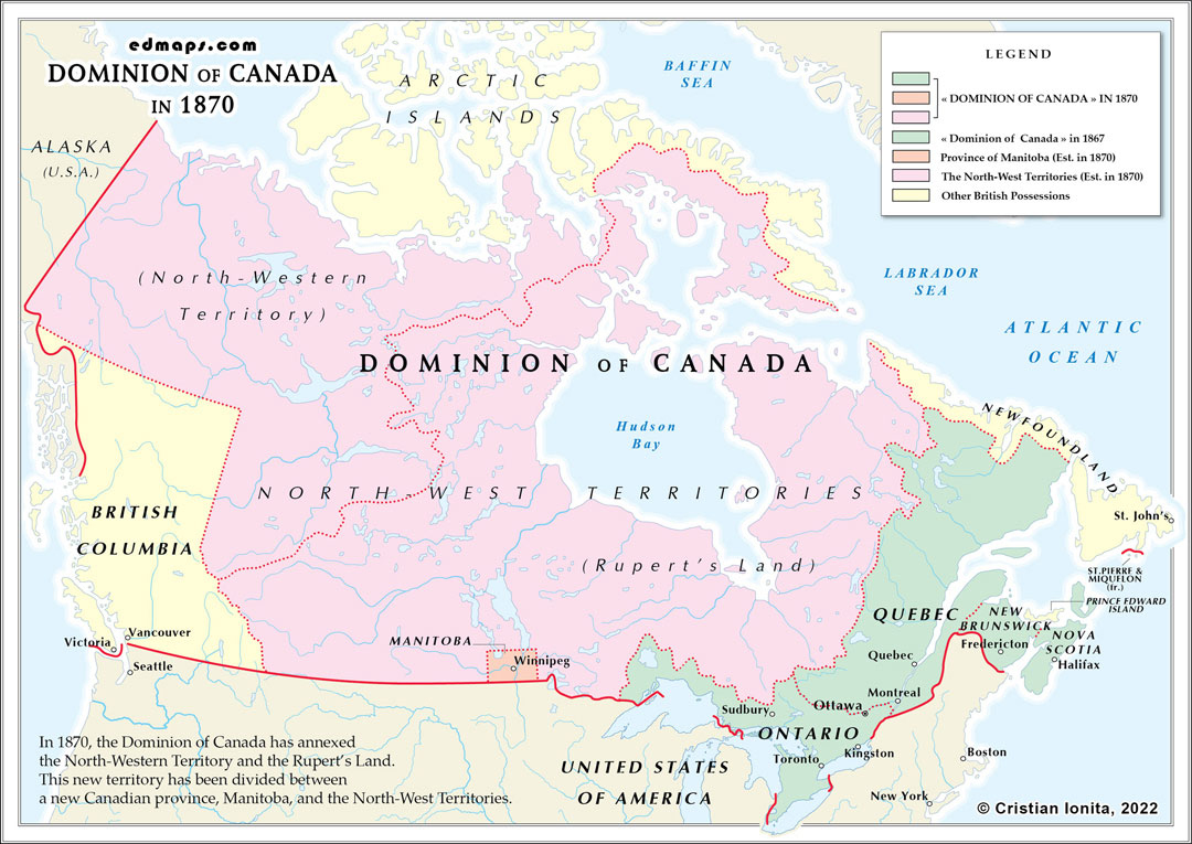
By 1870, the Dominion of Canada had begun its westward expansion with the acquisition of Rupert's Land and the creation of Manitoba, significantly transforming its territorial scope and administrative structure.
The Dominion now comprised five provinces following Manitoba's creation in 1870. Ontario, Quebec, Nova Scotia, and New Brunswick remained the original four provinces from Confederation. Manitoba, carved from the Red River Colony, became the fifth province with approximately 12,000 inhabitants, including a substantial Métis population whose rights were protected under the Manitoba Act.
The Hudson's Bay Company's transfer of Rupert's Land to Canada in 1870 created the vast Northwest Territories, encompassing present-day Saskatchewan, Alberta, most of the Arctic, and portions of Ontario and Quebec. This acquisition added approximately 2.5 million square miles to the Dominion, extending Canadian territory from the Great Lakes to the Arctic Ocean and Rocky Mountains. The Northwest Territories remained under direct federal administration with a lieutenant governor and appointed council.
British Columbia and Prince Edward Island remained separate British crown colonies outside the Dominion. British Columbia, formed by the union of Vancouver Island and mainland British Columbia in 1866, was considering confederation but had not yet joined. Prince Edward Island continued as an independent colony, resistant to confederation terms.
The federal government in Ottawa administered the Northwest Territories directly through the Department of the Secretary of State, while provinces maintained their constitutional powers over local matters. Manitoba received provincial status immediately due to the Red River Rebellion, unlike typical territorial progression patterns.
Managing the enormous Northwest Territories with minimal population and infrastructure presented unprecedented administrative challenges. The government established a basic territorial administration while planning future provincial creation as settlement increased.
The 1870 expansion represented a crucial step toward realizing the Confederation founders' vision of a transcontinental dominion stretching from sea to sea.
Sources, Methodology & Educational Use: The maps presented on this page are original creations produced for edmaps.com by Dr. Cristian Ionita. Each map is based on verified historical data relating to the territorial evolution, administrative structures, and political history of Canada. The maps are designed according to established practices in historical cartography, including source analysis, period contextualization, and visual clarity. The collection is curated to support teaching, learning, and public understanding of Canadian history, and is intended for educational and non‑commercial use.
edmaps.com — Historical Cartography for Education
edmaps.com provides original maps and curated historical maps designed to support teaching, learning, and public understanding of territorial evolution and administrative history. The original maps are created by Cristian Ionita, and all curated maps are selected from public archives, historical collections, and private holdings, and are presented for educational and non‑commercial use.
© Cristian Ionita. All rights reserved.
Website: https://edmaps.com — Contact: info@edmaps.com
