
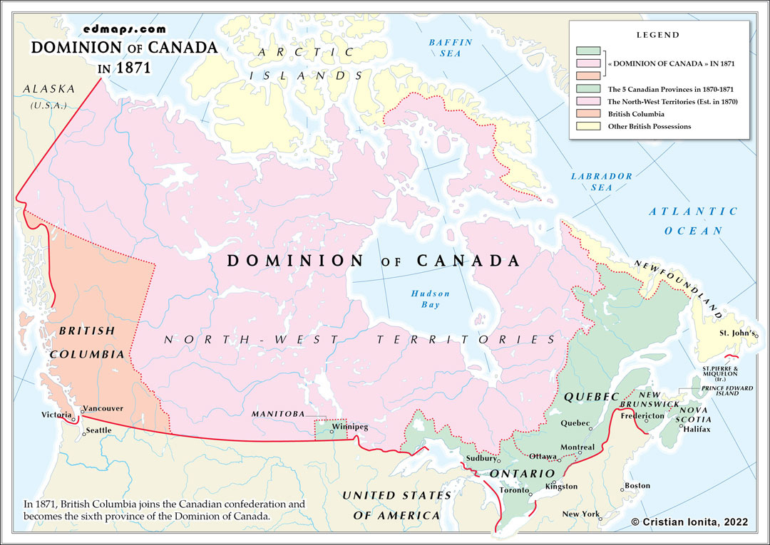
By 1871, the Dominion of Canada had achieved a crucial milestone in its transcontinental vision with British Columbia's entry, creating a federation spanning from the Atlantic to the Pacific Ocean.
The Dominion now comprised six provinces following British Columbia's confederation on July 20, 1871. The original four provinces (Ontario, Quebec, Nova Scotia, and New Brunswick) were joined by Manitoba (1870) and British Columbia (1871). British Columbia's entry was secured through federal promises to assume the colony's debts and construct a transcontinental railway within ten years, connecting the Pacific province to eastern Canada.
The vast Northwest Territories remained under direct federal administration, encompassing present-day Saskatchewan, Alberta, Yukon, Northwest Territories, Nunavut, and portions of Ontario, Quebec, and Manitoba. This enormous territory was governed by a lieutenant governor and appointed council from the territorial capital at Fort Garry (Winnipeg), though effective administration remained minimal across such vast distances.
Ontario contained approximately 1.6 million inhabitants and controlled the Great Lakes region's economic heartland. Quebec retained its distinct French character with 1.2 million residents, preserving civil law and Catholic institutions. The Maritime provinces, Nova Scotia (387,000) and New Brunswick (285,000), maintained their established governmental structures. Manitoba (25,000) protected Métis rights and bilingual institutions. British Columbia (36,000) brought Pacific coastal territories and significant Indigenous populations.
Each province possessed its own lieutenant governor, premier, and bicameral or unicameral legislature, while the federal government in Ottawa controlled defense, trade, criminal law, and territorial administration. The federal Parliament consisted of the House of Commons and Senate, with representation adjusted to include British Columbia's four senators and six members of parliament.
Only Prince Edward Island remained outside Confederation among the original British North American colonies, though it was under increasing pressure to join due to financial difficulties and railway debt.
Sources, Methodology & Educational Use: The maps presented on this page are original creations produced for edmaps.com by Dr. Cristian Ionita. Each map is based on verified historical data relating to the territorial evolution, administrative structures, and political history of Canada. The maps are designed according to established practices in historical cartography, including source analysis, period contextualization, and visual clarity. The collection is curated to support teaching, learning, and public understanding of Canadian history, and is intended for educational and non‑commercial use.
edmaps.com — Historical Cartography for Education
edmaps.com provides original maps and curated historical maps designed to support teaching, learning, and public understanding of territorial evolution and administrative history. The original maps are created by Cristian Ionita, and all curated maps are selected from public archives, historical collections, and private holdings, and are presented for educational and non‑commercial use.
© Cristian Ionita. All rights reserved.
Website: https://edmaps.com — Contact: info@edmaps.com
