
Following the Treaty of Ryswick in September 1697, which ended the War of the League of Augsburg (King William's War), New France experienced significant territorial and administrative adjustments that shaped its continental empire.
The Treaty of Ryswick confirmed French sovereignty over most of New France's vast territorial claims, including Canada (the St. Lawrence valley), Louisiana (the Mississippi watershed), and the western Great Lakes region. However, France was forced to return captured territories, including parts of Newfoundland and Hudson Bay posts to England. The treaty established clearer, though still disputed, boundaries between French and English territorial claims in North America.
The royal government structure established in 1663 continued governing the expanded empire. The Governor-General maintained supreme authority from Quebec City over military affairs and Native American relations, while the Intendant managed civil administration, justice, and economic development. The Sovereign Council served judicial and limited legislative functions for the entire French North American empire.
New France effectively operated through three distinct administrative regions: Canada proper (St. Lawrence settlements), Acadia (though much reduced by English territorial gains), and Louisiana (the vast Mississippi valley claims). Each region required adapted governance due to enormous distances and distinct local conditions.
French territorial control depended on an extensive network of forts and trading posts extending from the Atlantic to the Great Lakes and down the Mississippi. Key installations included Fort Frontenac, Michilimackinac, Detroit (established 1701), and various Illinois country posts. This network facilitated fur trade and maintained crucial Native American alliances.
Despite territorial confirmation, New France's population remained approximately 15,000 colonists concentrated along the St. Lawrence River. Governing territories covering millions of square miles with such limited population created persistent administrative difficulties, requiring heavy reliance on indigenous allies and strategic trading relationships rather than direct settlement and control.
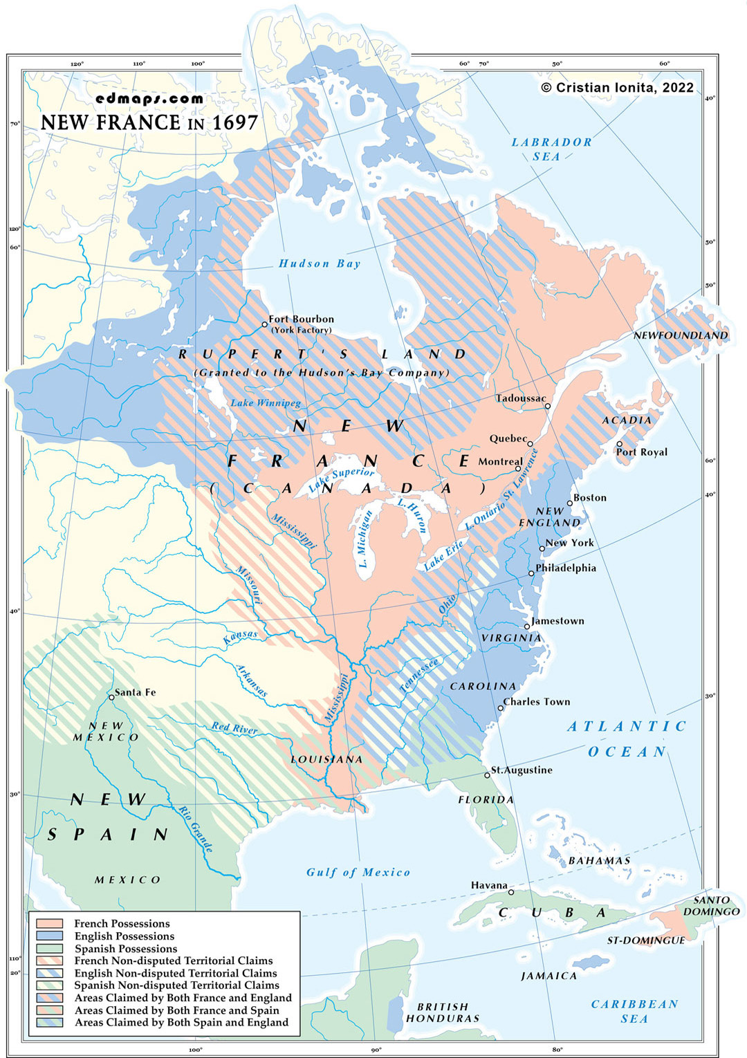
Sources, Methodology & Educational Use: The maps presented on this page are original creations produced for edmaps.com by Dr. Cristian Ionita. Each map is based on verified historical data relating to the territorial evolution, administrative structures, and political history of Canada. The maps are designed according to established practices in historical cartography, including source analysis, period contextualization, and visual clarity. The collection is curated to support teaching, learning, and public understanding of Canadian history, and is intended for educational and non‑commercial use.
edmaps.com — Historical Cartography for Education
edmaps.com provides original maps and curated historical maps designed to support teaching, learning, and public understanding of territorial evolution and administrative history. The original maps are created by Cristian Ionita, and all curated maps are selected from public archives, historical collections, and private holdings, and are presented for educational and non‑commercial use.
© Cristian Ionita. All rights reserved.
Website: https://edmaps.com — Contact: info@edmaps.com
