
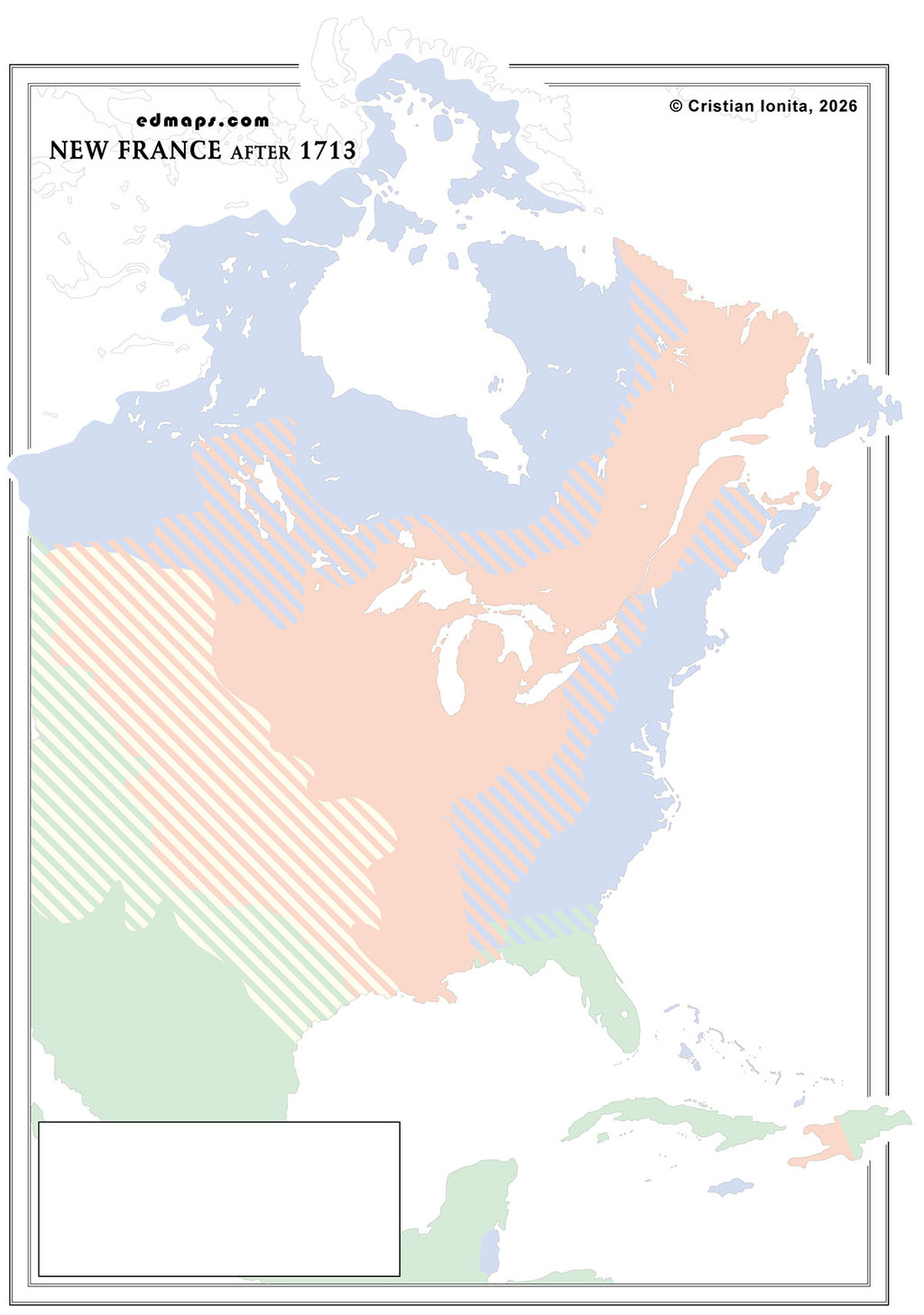
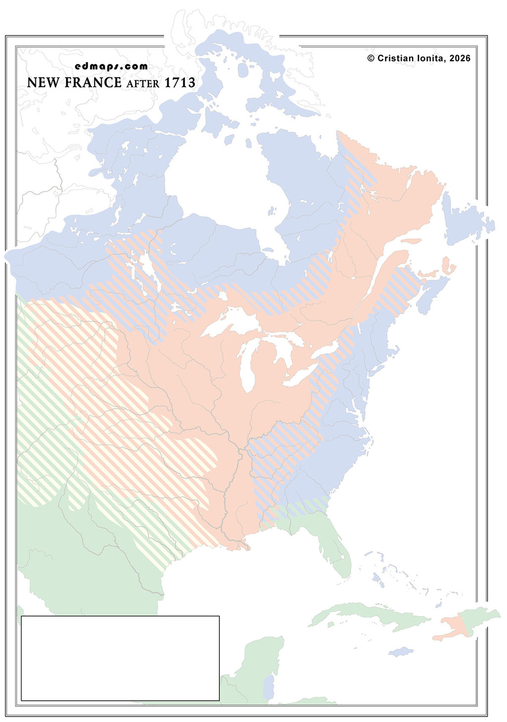
Following the Treaty of Utrecht (1713), which ended the War of Spanish Succession, New France experienced significant territorial losses that fundamentally altered its administrative structure and strategic position in North America.
The treaty forced France to cede Acadia (Nova Scotia), Newfoundland, and Hudson Bay territories to Britain, dramatically reducing New France's Atlantic presence. However, France retained Cape Breton Island (Isle Royale) and Prince Edward Island (Isle Saint-Jean), along with fishing rights on Newfoundland's northern shore. The core territories of Canada (St. Lawrence valley) and Louisiana (Mississippi watershed) remained under French control, preserving New France's continental claims.
New France was effectively reorganized into four major administrative regions following the territorial adjustments. Canada proper continued encompassing the St. Lawrence River valley from Quebec to Montreal, housing approximately 18,000 French colonists under the traditional Governor-General and Intendant system based in Quebec City.
France developed Isle Royale as a fortified replacement for lost Acadia, establishing Louisbourg as a massive fortress-city and administrative capital. This strategic position aimed to protect the St. Lawrence approaches and maintain French naval presence in the Atlantic, while serving as a base for the crucial cod fishery.
In 1717, the Illinois Country (Pays des Illinois) is annexed to Louisiana, and this bigger province will be divided into Upper Louisiana (Illinois Country) and Lower Louisiana (centered on New Orleans), administered separately from Canada due to vast distances. The Mississippi valley territories maintained semi-autonomous governance under military commandants, with New Orleans serving as the commercial and administrative hub.
The Great Lakes region and western fur trading territories continued operating under the Pays d'en Haut administrative system, governed through military posts at Detroit, Michilimackinac, and other strategic locations.
The territorial losses significantly weakened New France's strategic position, eliminating the Acadian buffer against British expansion while concentrating French power in more defensible but isolated territories, setting the stage for future conflicts over remaining French North American claims.

Sources, Methodology & Educational Use: The maps presented on this page are original creations produced for edmaps.com by Dr. Cristian Ionita. Each map is based on verified historical data relating to the territorial evolution, administrative structures, and political history of Canada. The maps are designed according to established practices in historical cartography, including source analysis, period contextualization, and visual clarity. The collection is curated to support teaching, learning, and public understanding of Canadian history, and is intended for educational and non‑commercial use.
edmaps.com — Historical Cartography for Education
edmaps.com provides original maps and curated historical maps designed to support teaching, learning, and public understanding of territorial evolution and administrative history. The original maps are created by Cristian Ionita, and all curated maps are selected from public archives, historical collections, and private holdings, and are presented for educational and non‑commercial use.
© Cristian Ionita. All rights reserved.
Website: https://edmaps.com — Contact: info@edmaps.com
