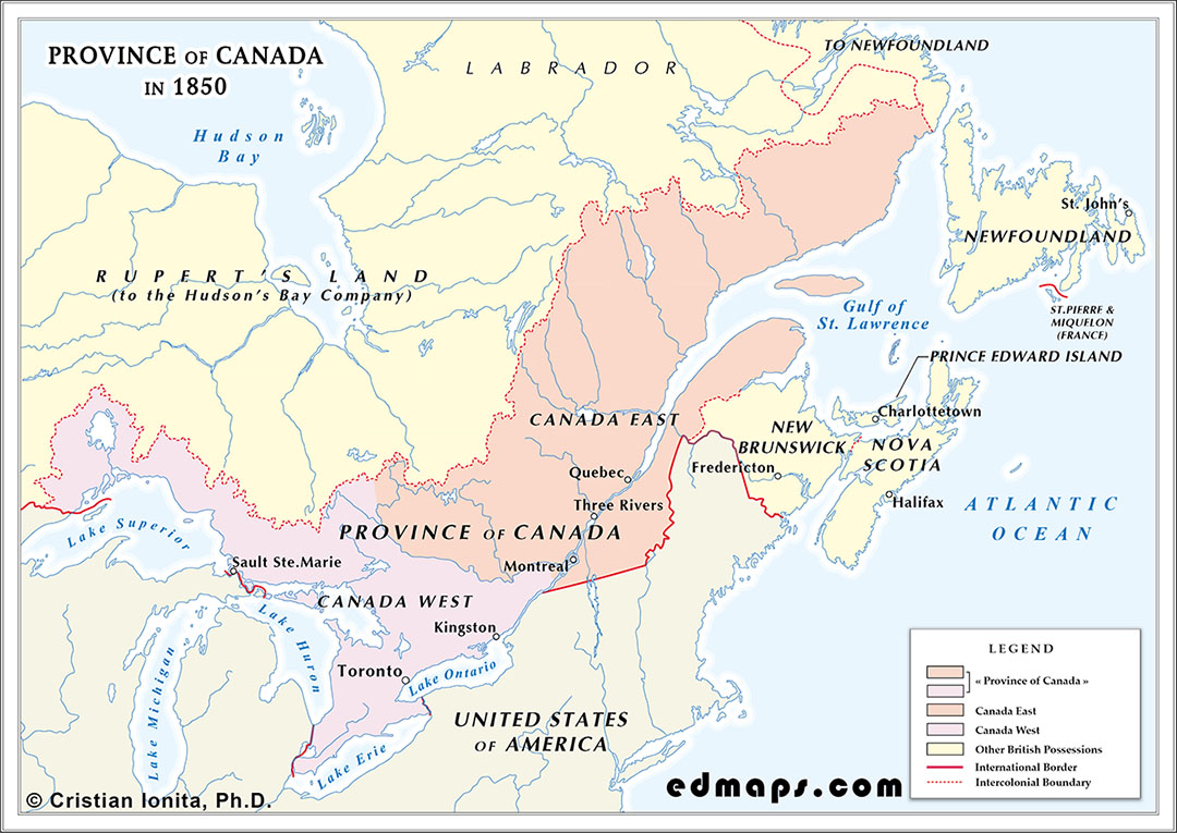
By 1850, the Province of Canada, created by the Act of Union in 1840, remained a single political unit composed of two distinct sections, Canada East and Canada West, each preserving its own legal traditions, religious institutions, and cultural identities. Canada East was still predominantly French‑speaking and Catholic, governed by French civil law, while Canada West was largely English‑speaking and Protestant, operating under English common law. Equal representation in the Legislative Assembly continued to bind the two sections together despite the rapid demographic expansion of Canada West, which increasingly challenged the political balance envisioned in 1840.
The population of the united province approached nearly 1.8 million inhabitants by mid‑century, with immigration, especially from the British Isles, fueling the growth of Canada West. Canada East remained slightly more populous but more rural, shaped by the seigneurial system and a strong clerical presence. Political life was marked by recurrent deadlock, as neither section could impose its will on the other, and as debates over language, education, and public finance intensified.
In 1850, the capital of the Province of Canada was Toronto, a status it held because the government had abandoned Montreal after the 1849 Rebellion Losses Bill riots and had not yet settled on a permanent seat. Toronto served as a politically safer and more neutral choice for Canada West while negotiations continued over a long‑term capital acceptable to both sections.
The territorial limits of the Province of Canada in 1850 were those inherited from the Union of 1840, now clarified by the diplomatic settlements between Britain and U.S.A.. The internal boundary between Canada East and Canada West followed the Ottawa River, while the eastern frontier of the province was defined by the line separating Canada East from New Brunswick and from the Labrador coast administered under Newfoundland. The long‑standing dispute over the New Brunswick–Maine boundary, which had produced the Aroostook tensions, had been definitively settled by the Webster–Ashburton Treaty of 1842, fixing the border from the upper St. John valley to the headwaters of the Connecticut River. To the south, the frontier followed the St. Lawrence River and the Great Lakes as established by earlier Anglo‑American treaties. To the west, the province extended to the upper Great Lakes (Lake Huron and Lake Superior), beyond which stretched the vast, undefined territories of Rupert’s Land under the authority of the Hudson’s Bay Company.
Elsewhere in British North America, Nova Scotia, New Brunswick, Prince Edward Island, and Newfoundland remained separate colonies with their own administrations, while the immense interior of Rupert’s Land and the Northwestern Territory continued under the Hudson’s Bay Company, still largely outside the orbit of Canadian political life.