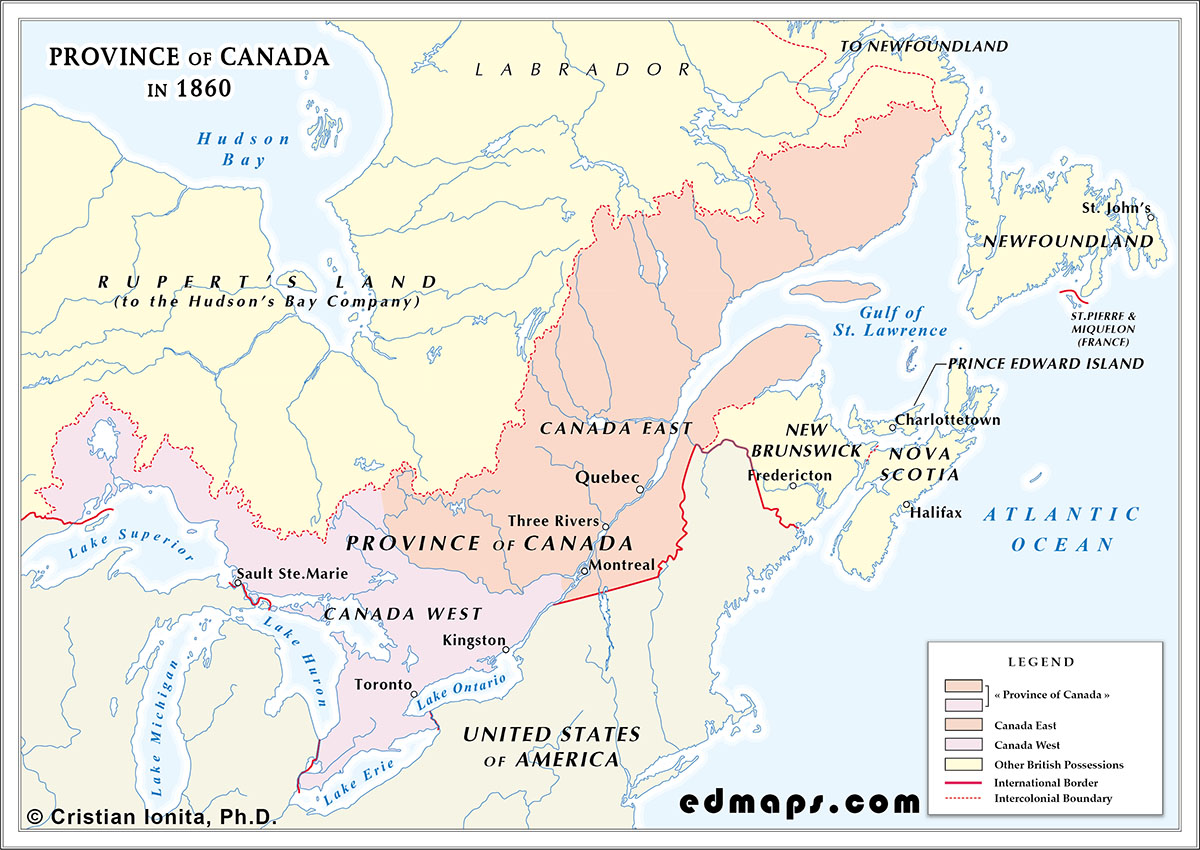
By 1860, the Province of Canada, still governed as a single political entity uniting Canada East and Canada West, had entered a period of accelerated demographic growth and mounting political strain. The institutional framework created by the Act of Union in 1840 remained intact, but the balance between the two sections had shifted markedly, and the limitations of the union were becoming increasingly apparent.
Canada East preserved its French-speaking and Catholic character, anchored in civil law, parish institutions, and a social order still shaped by the legacy of the seigneurial system, formally abolished only a few years earlier. Canada West, by contrast, had become the demographic engine of the province, drawing large numbers of immigrants from the British Isles and developing a more urban, commercial, and Protestant profile. The principle of equal representation in the Legislative Assembly, originally intended to stabilize the union, now produced chronic deadlock, as Canada West’s larger population demanded representation by population while Canada East sought to preserve its political weight.
The population of the united province exceeded 2.5 million inhabitants by 1860, with Canada West now clearly more populous. Industrialization was beginning to take root in the St. Lawrence corridor and the Great Lakes region, while railway construction, most notably the Grand Trunk Railway, was reshaping patterns of trade and communication. Despite these developments, political life remained marked by fragile coalitions, sectional rivalries, and recurrent ministerial instability.
In 1860, the capital of the Province of Canada was Quebec, following the decision of Queen Victoria in 1857 to designate Ottawa as the future permanent seat of government. While Ottawa was still under construction and not yet ready to host the legislature, Quebec served as the interim capital, offering administrative continuity and a symbolic balance between the two sections of the province.
The territorial limits of the Province of Canada in 1860 were those defined by the Union of 1840 and the diplomatic settlements of the preceding decades. The internal boundary between Canada East and Canada West continued to follow the Ottawa River and the line of the old Upper–Lower Canada division. To the east, the frontier with New Brunswick and the Labrador coast administered under Newfoundland remained stable. To the south, the border with the United States followed the St. Lawrence River, the Great Lakes, and the 45th parallel, as established by earlier Anglo‑American treaties. To the west, the province reached the upper Great Lakes, beyond which lay the vast territories of Rupert’s Land and the Northwestern Territory under the authority of the Hudson’s Bay Company.
By 1860, the province occupied an increasingly central position within Britain’s North American possessions, not because of constitutional harmony but because of its expanding economic and geographic reach. The rapid growth of railways, the consolidation of Great Lakes commerce, and the emergence of new urban centres were drawing the province westward, linking its future more closely to the continental interior than to the older Atlantic colonies. While Nova Scotia, New Brunswick, Prince Edward Island, and Newfoundland continued to follow their own political trajectories, the Province of Canada was developing into the principal axis of British North America, its internal tensions, demographic contrasts, and ambitious infrastructure projects revealing both the possibilities and the limits of the union created in 1840.